By Raymond Carl Dela Cruz
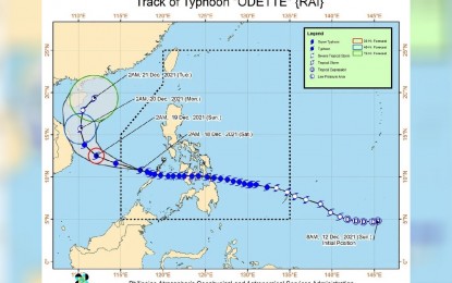
(Image from the Department of Science and Technology-PAGASA)
MANILA – Blustery winds and pelting rains are expected in parts of Luzon as Typhoon Odette maintained its strength on Saturday, moving towards the Kalayaan Island at 15 kph.
In its 5 a.m. tropical cyclone bulletin, the Philippine Atmospheric, Geophysical and Astronomical Services Administration (PAGASA) said the center of the eye of the typhoon was last located at 240 km. west-northwest of Puerto Princesa, Palawan.
“Odette” continues to pack maximum sustained winds of 150 kph near the center, gustiness of up to 185 kph, and strong winds or higher extending outwards up to 400 km. from the center.
PAGASA has raised Tropical Cyclone Wind Signal (TCWS) No. 3 in the Kalayaan Islands, signaling possible destructive typhoon-force winds in the area within the next 18 hours.
TCWS No. 2 is raised in the central portion of Palawan – San Vicente, Quezon, Puerto Princesa City, and Aborlan – signaling damaging gale to storm-force winds within 24 hours.
TCWS No. 1 is raised over the rest of mainland Palawan, including the Calamian Islands due to strong winds expected within 36 hours.
The bureau said there may be heavy to torrential rains over the Kalayaan Islands while there may be moderate to heavy rains over mainland Palawan, Aurora, and the northern portion of Quezon, including the Polillo Islands.
It forecast light to moderate with at times heavy rains over the Bicol region, Northern Samar, Nueva Vizcaya, Quirino, Nueva Ecija, and the rest of Quezon.
In the next 24 hours, there may be rough to very high seas (2.8 meters to 10 meters) over the seaboards of areas where TCWS No. 3 is in effect, especially in the open seas.
“Rough to very rough seas (2.8 meters to 5 meters) will also continue for the seaboards of areas under TCWS Nos. 2 and 1. These conditions are risky for all types of sea vessels,” PAGASA said.
The typhoon, it said, may exit the Philippine Area of Responsibility by Saturday morning or afternoon. (PNA)
